Skip navigation
Browse
Communities
& Collections
Browse Items by:
Year of publication
Author
Title
Date
Subject
Type
Series
Submit Date
Corporate
Governance
Agency organisational structure
Annual Reports
Corporate plans
GBR outlook report
Partnerships and agreements
Policies and position statements
Information Publication Scheme
Ecosystems
& Species
Animals
Plants
Ecosystems
Processes
Geographic features
Reef
Values
Cultural heritage
National heritage
Natural heritage
World heritage
Economic values
Social values
Managing
Multiple Use
Agriculture
Coastal development
Commercial fisheries
Defence
Illegal activity
Mining
Ports and shipping
Recreation
Research
Tourism
Traditional use
Leading environmental practice
Legislative tools
Permits and assessments
Zones, plans and maps
Effects
on the Reef
Climate change
Extreme events
Incidents
Water quality
Weeds, pests and disease
People
& Actions
Coastal communities
Councils
Farmers and graziers
Fishers
Miners
Recreational users
Reef managers
Schools
Tourism operators
Traditional owners
Sign on to:
My ELibrary
Receive email
updates
Edit Profile
Welcome to The Reef Authority
Great Barrier Reef Marine Park Authority
Reef Authority Digital Repository
Browsing by Type Map
Jump to:
0-9
A
B
C
D
E
F
G
H
I
J
K
L
M
N
O
P
Q
R
S
T
U
V
W
X
Y
Z
or enter first few letters:
Sort by:
title
issue date
submit date
In order:
Ascending
Descending
Results/Page
5
10
15
20
25
30
35
40
45
50
55
60
65
70
75
80
85
90
95
100
Authors/Record:
All
1
5
10
15
20
25
30
35
40
45
50
Showing results 1 to 20 of 126
next >
View
Date
Title
Author(s)
Type
2019
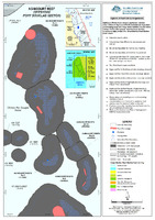
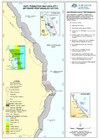
Agincourt Reef (Offshore Port Douglas Sector)
Spatial Data Centre
Map
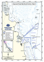
2006
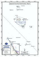
Approved Cruise Ship Transit Corridors - Map A
Great Barrier Reef Marine Park Authority
Map
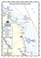
2006
Approved Cruise Ship Transit Corridors - Map B
Great Barrier Reef Marine Park Authority
Map
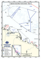
2006
Approved Cruise Ship Transit Corridors - Map C
Great Barrier Reef Marine Park Authority
Map
2006
Approved Cruise Ship Transit Corridors - Map D
Great Barrier Reef Marine Park Authority
Map
2005
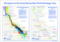
Bioregions of the Great Barrier Reef World Heritage Area
Great Barrier Reef Marine Park Authority
Map
2005
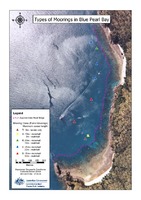
Blue Pearl Bay mooring map (REVOKED)
Great Barrier Reef Marine Park Authority
Map
2008
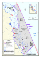
Cairns planning area (SUPERSEDED)
Great Barrier Reef Marine Park Authority
Map
2019
Cape Tribulation Bay Locality 1 (Offshore Port Douglas Sector)
Spatial Data Centre
Map
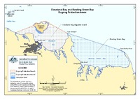
2013
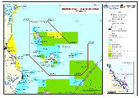
Cleveland Bay and Bowling Green Bay dugong protected areas
Great Barrier Reef Marine Park Authority
Map
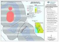
2019
Cod Hole Locality (Ribbon Reefs Sector)
Spatial Data Centre
Map
2021
Darumbal TUMRA
Great Barrier Reef Marine Park Authority
Map
2017
Designated anchorages in the Great Barrier Reef Marine Park
Great Barrier Reef Marine Park Authority
;
Queensland Government
Map
2004
Designated Shipping Areas within the Great Barrier Reef Marine Park
Spatial Data Centre
Map
2021
Determined Native Title and Traditional Use of Marine Resources Agreement (TUMRA) areas in the Great Barrier Reef Marine Park
Great Barrier Reef Marine Park Authority
Map
2007
Dharumbal TUMRA - Woppaburra Section Schedule 3 map (SUPERSEDED)
Great Barrier Reef Marine Park Authority
Map
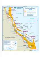
2002
DRAFT 26.04.02 Great Barrier Reef Marine Park zoning and adjacent conservation reserves
Great Barrier Reef Marine Park Authority
Map
2013
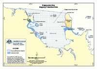
Edgecumbe Bay dugong protected areas
Great Barrier Reef Marine Park Authority
Map
2018
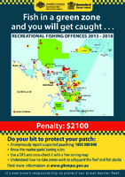
Fish in a green zone and you will get caught...Recreational fishing offences 2013-2018 Airlie Beach
Great Barrier Reef Marine Park Authority
;
Queensland Government
Map
2018
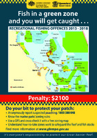
Fish in a green zone and you will get caught...Recreational fishing offences 2013-2018 Cairns
Great Barrier Reef Marine Park Authority
;
Queensland Government
Map