Welcome to The Reef Authority
Great Barrier Reef Marine Park Authority
Please use this identifier to cite or link to this item:
https://hdl.handle.net/11017/3519
![]()
| Title: | Approved Cruise Ship Transit Corridors - Map A |
| Authors: | Great Barrier Reef Marine Park Authority |
| metadata.dc.subject.asfa: | Shipping |
| APAIS Subject: | Shipping |
| metadata.dc.subject.location: | Far Northern Management Area |
| metadata.dc.subject.category: | Ports and shipping Zones, plans and maps |
| Year of publication: | 2006 |
| Publisher: | Great Barrier Reef Marine Park Authority |
| Description: | Map No. SDC050534 (Map A) 7 November 2006. This map is indicative only. |
| URI: | https://hdl.handle.net/11017/3519 |
| Type of document: | Map |
| Appears in Collections: | Management |
Files in This Item:
| File | Description | Size | Format | |
|---|---|---|---|---|
| SDC050534-Cruise-Ship-Transit-Areas-Map-A-07-Nov-2006.pdf | map | 641.14 kB | Adobe PDF | 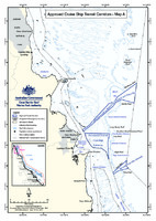 View/Open |
Items in ELibrary are protected by copyright, with all rights reserved, unless otherwise indicated.