Welcome to The Reef Authority
Great Barrier Reef Marine Park Authority
Please use this identifier to cite or link to this item:
https://hdl.handle.net/11017/3670

Full metadata record
| DC Field | Value | Language |
|---|---|---|
| dc.date.accessioned | 2020-11-25T03:04:20Z | - |
| dc.date.available | 2020-11-25T03:04:20Z | - |
| dc.date.copyright | 2005 | en |
| dc.date.issued | 2005 | en |
| dc.identifier.uri | https://hdl.handle.net/11017/3670 | - |
| dc.description | GBRMPA MAP No. SDC 050517 May 2005 (2 individual maps appear side-by-side in this bigger map product, both maps dated March 2001). Map contains a warning/ disclaimer. | en |
| dc.description.abstract | [Extract] The bioregions shown on both maps were defined by a panel of experts in the GBR region, using the best data and regional analysis available to GBRMPA from 1999-2001. The maps represent concensus among the experts on the delineation of 'bioregions' within the Great Barrier Reef Marine Park. | en |
| dc.publisher | Great Barrier Reef Marine Park Authority | en |
| dc.rights | © Commonwealth of Australia. This map is licenced under a Creative Commons By Attribution No Derivatives 4.0 International licence, with the exception of the crest of the Commonwealth of Australia. For licence conditions please visit https://creativecommons.org/licenses/by-nd/4.0/ | en |
| dc.subject.other | Reef Ecosystems & Marine Species | en |
| dc.title | Bioregions of the Great Barrier Reef World Heritage Area | en |
| dc.type | Map | en |
| dc.subject.asfa | bioregion | en |
| dc.format.pages | 1 | en |
| dc.contributor.corpauthor | Great Barrier Reef Marine Park Authority | en |
| dc.publisher.place | Townsville | en |
| dc.relation.connectiontogbrmpa | GBRMPA published this item | en |
| dc.subject.category | Ecosystems | en |
| dc.subject.location | Reef-wide | en |
| Appears in Collections: | Ecosystems | |
Files in This Item:
| File | Description | Size | Format | |
|---|---|---|---|---|
| SDC050517_Bioregions of the GBRWH Area.jpg | Map (JPG) | 7.8 MB | JPEG |  View/Open |
| SDC050517_Bioregions of the GBRWH Area.pdf | Map (PDF) | 1.87 MB | Adobe PDF | 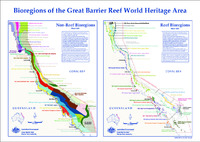 View/Open |
This item is licensed under a Creative Commons License
