Welcome to The Reef Authority
Great Barrier Reef Marine Park Authority
Please use this identifier to cite or link to this item:
https://hdl.handle.net/11017/856
Full metadata record
| DC Field | Value | Language |
|---|---|---|
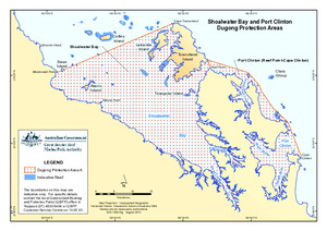
| dc.coverage.spatial | Shoalwater Bay (Dugong) Plan of Management Area | en |
| dc.date.accessioned | 2012-10-29T04:29:54Z | null |
| dc.date.available | 2012-10-29T04:29:54Z | null |
| dc.date.copyright | 2013 | en |
| dc.date.issued | 2013 | en |
| dc.identifier.uri | https://hdl.handle.net/11017/856 | null |
| dc.publisher | Great Barrier Reef Marine Park Authority | en |
| dc.relation.ispartofseries | Special Management Areas | null |
| dc.title | Shoalwater Bay and Port Clinton dugong protection areas | en |
| dc.type | Map | * |
| dc.subject.asfa | Maps | en |
| dc.description.notes | Previous/Superseded title: Shoalwater Bay (Dugong) planning area map 2005 | en |
| dc.contributor.corpauthor | Great Barrier Reef Marine Park Authority | en |
| dc.subject.apais | Environmental management | en |
| dc.publisher.place | Townsville | en |
| dc.subject.collection | Managing Multiple Use | en |
| dc.relation.connectiontogbrmpa | GBRMPA published this item | en |
| dc.subject.category | Information Publication Scheme | en |
| dc.subject.category | Zones, plans and maps | en |
| Appears in Collections: | Management | |
Files in This Item:
| File | Description | Size | Format | |
|---|---|---|---|---|
| 130610g-GBRMPAandStateDPAs-ShoalwaterBay-2013.pdf | Current map | 798.99 kB | Adobe PDF | 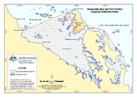 View/Open |
| SUPERSEDED-shoalwater-bay-planning-area-map-2005.pdf | SUPERSEDED map | 581.86 kB | Adobe PDF | 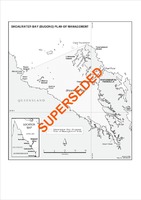 View/Open |
Items in ELibrary are protected by copyright, with all rights reserved, unless otherwise indicated.