Welcome to The Reef Authority
Great Barrier Reef Marine Park Authority
Please use this identifier to cite or link to this item:
https://hdl.handle.net/11017/615
Full metadata record
| DC Field | Value | Language |
|---|---|---|
| dc.date.accessioned | 2012-10-24T00:22:37Z | null |
| dc.date.available | 2012-10-24T00:22:37Z | null |
| dc.date.copyright | 2016 | en |
| dc.date.issued | 2017 | en-US |
| dc.identifier.uri | https://hdl.handle.net/11017/615 | - |
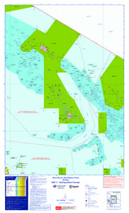
| dc.description.abstract | Zoning map of Hydrographers Passage - Edition V | en |
| dc.publisher | Great Barrier Reef Marine Park Authority | en |
| dc.relation.ispartofseries | Zoning Maps | en |
| dc.relation.ispartofseries | Great Barrier Reef Zoning Maps | en |
| dc.title | Great Barrier Reef Marine Parks Zoning MAP 11 - Hydrographers Passage | en |
| dc.type | Map | * |
| dc.subject.asfa | Coastal zone management | en |
| dc.subject.asfa | Maps | en |
| dc.description.notes | Replaces Edition IV (2011). | en |
| dc.contributor.corpauthor | Great Barrier Reef Marine Park Authority | en |
| dc.subject.apais | Environmental management | en |
| dc.subject.apais | Mapping | en |
| dc.publisher.place | Townsville | en |
| dc.subject.collection | Managing Multiple Use | en |
| dc.relation.connectiontogbrmpa | GBRMPA published this item | en |
| dc.subject.category | Information Publication Scheme | en |
| dc.subject.category | Zones, plans and maps | en |
| dc.subject.location | Townsville/Whitsunday Management Area | en |
| Appears in Collections: | Management | |
Files in This Item:
| File | Description | Size | Format | |
|---|---|---|---|---|
| WEB_Map11_Merge.pdf | Current | 8.92 MB | Adobe PDF |  View/Open |
| SUPERSEDED-Map11-Hydrographers-Passage-2011.pdf | Superseded | 4.74 MB | Adobe PDF | 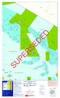 View/Open |
| Superseded Map11-EditionV-Hydrographers-Passage.pdf | Superseded | 2.31 MB | Adobe PDF |  View/Open |
Items in ELibrary are protected by copyright, with all rights reserved, unless otherwise indicated.