Welcome to The Reef Authority
Great Barrier Reef Marine Park Authority
Please use this identifier to cite or link to this item:
https://hdl.handle.net/11017/4145
Full metadata record
| DC Field | Value | Language |
|---|---|---|
| dc.date.accessioned | 2025-11-11T22:34:32Z | - |
| dc.date.available | 2025-11-11T22:34:32Z | - |
| dc.date.copyright | 2010 | en |
| dc.date.issued | 2010 | en |
| dc.identifier.uri | https://hdl.handle.net/11017/4145 | - |
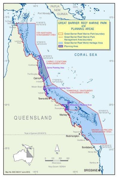
| dc.description.abstract | Map of the Great Barrier Reef boundaries and planning area locations 2010 | en |
| dc.publisher | Great Barrier Reef Marine Park Authority | en |
| dc.rights | Attribution-NoDerivs 3.0 Australia | en |
| dc.rights.uri | http://creativecommons.org/licenses/by-nd/3.0/au/ | * |
| dc.title | GBR Boundaries and Planning Area Locations June 2010 | en |
| dc.type | Map | en |
| dc.subject.asfa | Long-term planning | en |
| dc.format.pages | 1 | en |
| dc.contributor.corpauthor | Great Barrier Reef Marine Park Authority | en |
| dc.subject.apais | Planning | en |
| dc.publisher.place | Townsville | en |
| dc.subject.collection | Managing Multiple Use | en |
| dc.relation.connectiontogbrmpa | GBRMPA published this item | en |
| dc.subject.category | Zones, plans and maps | en |
| dc.subject.location | Reef-wide | en |
| dc.keywords | map | en |
| dc.keywords | Great Barrier Reef Boundaries | en |
| dc.keywords | GBR Boundaries | en |
| dc.keywords | Great Barrier Reef planning area | en |
| dc.keywords | GBR planning area | en |
| Appears in Collections: | Management | |
Files in This Item:
| File | Description | Size | Format | |
|---|---|---|---|---|
| GBR Boundaries-and-PlanningAreaLocationsJune2010.pdf | 549.42 kB | Adobe PDF |  View/Open |
This item is licensed under a Creative Commons License
