Welcome to The Reef Authority
Great Barrier Reef Marine Park Authority
Please use this identifier to cite or link to this item:
https://hdl.handle.net/11017/4079
Full metadata record
| DC Field | Value | Language |
|---|---|---|
| dc.date.accessioned | 2024-08-26T03:09:51Z | - |
| dc.date.available | 2024-08-26T03:09:51Z | - |
| dc.date.copyright | 2024 | en |
| dc.date.issued | 2024 | en |
| dc.identifier.uri | https://hdl.handle.net/11017/4079 | - |
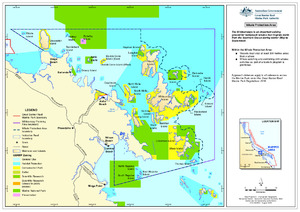
| dc.description.abstract | This map shows the Whale Protection Area which is within the Whitsunday Planning Area. | en |
| dc.publisher | Great Barrier Reef Marine Park Authority | en |
| dc.rights | Attribution-NoDerivatives 4.0 International | * |
| dc.rights.uri | http://creativecommons.org/licenses/by-nd/4.0/ | * |
| dc.title | Whale Protection Area map | en |
| dc.type | Map | en |
| dc.format.pages | 1 | en |
| dc.contributor.corpauthor | Great Barrier Reef Marine Park Authority | en |
| dc.publisher.place | Townsvile | en |
| dc.subject.collection | Managing Multiple Use | en |
| dc.relation.connectiontogbrmpa | GBRMPA published this item | en |
| dc.subject.category | Recreation | en |
| dc.subject.category | Tourism | en |
| dc.subject.location | Townsville/Whitsunday Management Area | en |
| dc.keywords | whale protection | en |
| dc.keywords | map | en |
| dc.keywords | Whitsundays whale | en |
| dc.keywords | whale | en |
| dc.keywords | whale protection area | en |
| Appears in Collections: | Management | |
Files in This Item:
| File | Description | Size | Format | |
|---|---|---|---|---|
| SDC240802-WhaleProtectionArea-SiteManagementArrangements.pdf | 3.87 MB | Adobe PDF |  View/Open |
This item is licensed under a Creative Commons License
