Welcome to The Reef Authority
Great Barrier Reef Marine Park Authority
Please use this identifier to cite or link to this item:
https://hdl.handle.net/11017/3582
Full metadata record
| DC Field | Value | Language |
|---|---|---|
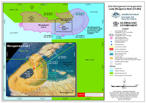
| dc.coverage.spatial | Lady Musgrave Reef (23-082) | en |
| dc.coverage.spatial | U/N Reef (23-082b) | en |
| dc.date.accessioned | 2020-04-02T00:04:10Z | - |
| dc.date.available | 2020-04-02T00:04:10Z | - |
| dc.date.copyright | 2015 | en |
| dc.date.issued | 2015 | en |
| dc.identifier.uri | https://hdl.handle.net/11017/3582 | - |
| dc.description | SDC 141104, February 2015. | en |
| dc.description.abstract | A map showing boundaries, pontoons, and other relevant information for the special site arrangements of the Lady Musgrave Reef complex. | en |
| dc.publisher | Great Barrier Reef Marine Park Authority | en |
| dc.relation.ispartofseries | Site Management Arrangements | en |
| dc.title | Site Management Arrangements: Lady Musgrave Reef (23-082) | en |
| dc.type | Map | en |
| dc.subject.asfa | Resource management | en |
| dc.subject.asfa | Protected areas | en |
| dc.contributor.corpauthor | Great Barrier Reef Marine Park Authority | en |
| dc.contributor.corpauthor | Queensland Government | en |
| dc.publisher.place | Townsville | en |
| dc.subject.collection | Managing Multiple Use | en |
| dc.relation.connectiontogbrmpa | GBRMPA published this item | en |
| dc.subject.category | Zones, plans and maps | en |
| dc.subject.location | Mackay/Capricorn Management Area | en |
| Appears in Collections: | Management | |
Files in This Item:
| File | Description | Size | Format | |
|---|---|---|---|---|
| 141104_LadyMusgrave_SiteManagement_Feb2015.pdf | Map (PDF) | 985.13 kB | Adobe PDF | 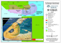 View/Open |
| 141104_LadyMusgrave_SiteManagement_Feb2015.jpg | Map (JPG) | 4.85 MB | JPEG |  View/Open |
Items in ELibrary are protected by copyright, with all rights reserved, unless otherwise indicated.