Welcome to The Reef Authority
Great Barrier Reef Marine Park Authority
Please use this identifier to cite or link to this item:
https://hdl.handle.net/11017/3520
![]()
Full metadata record
| DC Field | Value | Language |
|---|---|---|
| dc.coverage.spatial | Cruiser Passage | en |
| dc.coverage.spatial | One Mile Opening | en |
| dc.coverage.spatial | Lowry Passage to Melville Passage | en |
| dc.coverage.spatial | Cooktown | en |
| dc.date.accessioned | 2019-09-19T03:54:05Z | - |
| dc.date.available | 2019-09-19T03:54:05Z | - |
| dc.date.copyright | 2006 | en |
| dc.date.issued | 2006 | en |
| dc.identifier.uri | https://hdl.handle.net/11017/3520 | - |
| dc.description | Map No. SDC050534 (Map B) 7 November 2006. This map is indicative only. | - |
| dc.publisher | Great Barrier Reef Marine Park Authority | en |
| dc.rights | © Commonwealth of Australia (GBRMPA) | en |
| dc.title | Approved Cruise Ship Transit Corridors - Map B | en |
| dc.type | Map | en |
| dc.subject.asfa | Shipping | en |
| dc.contributor.corpauthor | Great Barrier Reef Marine Park Authority | en |
| dc.subject.apais | Shipping | en |
| dc.publisher.place | Townsville | en |
| dc.subject.collection | Managing Multiple Use | en |
| dc.relation.connectiontogbrmpa | GBRMPA published this item | en |
| dc.subject.category | Ports and shipping | en |
| dc.subject.category | Zones, plans and maps | en |
| dc.subject.location | Cairns/Cooktown Management Area | en |
| dc.keywords | shipping | en |
| dc.keywords | transit corridors | en |
| Appears in Collections: | Management | |
Files in This Item:
| File | Description | Size | Format | |
|---|---|---|---|---|
| SDC050534-Cruise-Ship-Transit-Areas-Map-B-07-Nov-2006.pdf | map | 554.23 kB | Adobe PDF | 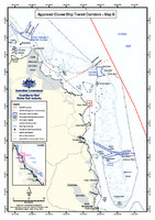 View/Open |
Items in ELibrary are protected by copyright, with all rights reserved, unless otherwise indicated.