Welcome to The Reef Authority
Great Barrier Reef Marine Park Authority
Please use this identifier to cite or link to this item:
https://hdl.handle.net/11017/3495

Full metadata record
| DC Field | Value | Language |
|---|---|---|
| dc.coverage.spatial | Clump Point | en |
| dc.date.accessioned | 2019-09-17T04:20:44Z | - |
| dc.date.available | 2019-09-17T04:20:44Z | - |
| dc.date.copyright | 2005 | en |
| dc.date.issued | 2005 | en |
| dc.identifier.uri | https://hdl.handle.net/11017/3495 | - |
| dc.description | SDC031105, 18 July 2005 | en |
| dc.publisher | Great Barrier Reef Marine Park Authority | en |
| dc.relation.ispartofseries | Site Management Arrangements | en |
| dc.relation.ispartofseries | Policy under s7(4) of the GBRMP Act 1975 | en |
| dc.rights | © Commonwealth of Australia (GBRMPA) | en |
| dc.title | Site Management Arrangements: Clump Point | en |
| dc.type | Map | en |
| dc.subject.asfa | Mooring buoys | en |
| dc.format.pages | 1 | en |
| dc.contributor.corpauthor | Great Barrier Reef Marine Park Authority | en |
| dc.publisher.place | Townsville | en |
| dc.subject.collection | Managing Multiple Use | en |
| dc.relation.connectiontogbrmpa | GBRMPA published this item | en |
| dc.subject.category | Zones, plans and maps | en |
| dc.subject.location | Cairns/Cooktown Management Area | en |
| dc.keywords | Installed moorings | en |
| Appears in Collections: | Management | |
Files in This Item:
| File | Description | Size | Format | |
|---|---|---|---|---|
| clump_point_locality_map.pdf | Map (PDF) | 1.05 MB | Adobe PDF | 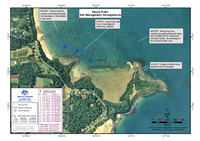 View/Open |
Items in ELibrary are protected by copyright, with all rights reserved, unless otherwise indicated.