Please use this identifier to cite or link to this item:
https://hdl.handle.net/11017/3442

| Title: | Douglas Shoal Remediation Project: visual surveys field report |
| Authors: | Advisian |
| metadata.dc.subject.asfa: | Underwater surveying Echo surveys |
| APAIS Subject: | Surveys |
| metadata.dc.subject.location: | Mackay/Capricorn Management Area |
| metadata.dc.subject.category: | Ecosystems Ports and shipping Incidents |
| Year of publication: | 2019 |
| Publisher: | Great Barrier Reef Marine Park Authority |
| Series/Report no.: | Douglas Shoal Remediation Project |
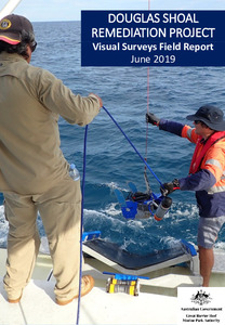
| Abstract: | The bulk carrier ‘Shen Neng 1’ ran aground on Douglas Shoal in April 2010 and remained on the reef for 10-days before being re-floated. The total area directly impacted was approximately 42 ha which makes this incident the largest ship grounding scar known in the Great Barrier Reef Marine Park, and possibly the largest reef-related direct shipping impact in the world. The Great Barrier Reef Marine Park Authority established the Douglas Shoal Remediation Project in late 2016 with funds from a court settlement associated with the grounding incident. The Project has as its primary desired outcome that remediation activities support natural recovery at Douglas Shoal.This Field Report is concerned with describing the visual seafloor survey fieldwork. The fieldwork included sonar (Multibeam Echo Sounding (MBES) and Sub Bottom Profiling (SBP)), drop camera and Towed Underwater Video (TUV) survey. |
| URI: | https://hdl.handle.net/11017/3442 |
| ISBN: | 9780648357148 |
| Type of document: | Report |
| Appears in Collections: | Effects |
Files in This Item:
| File | Description | Size | Format | |
|---|---|---|---|---|
| Visual-Surveys-Field-Report-June2019-v2.pdf | Main document (PDF) | 15.15 MB | Adobe PDF |  View/Open |
This item is licensed under a Creative Commons License

