Welcome to The Reef Authority
Great Barrier Reef Marine Park Authority
Please use this identifier to cite or link to this item:
https://hdl.handle.net/11017/3378
| Title: | Location of public moorings and Reef Protection Areas from Mission Beach to Townsville (updated to 2024 version) |
| Authors: | Great Barrier Reef Marine Park Authority |
| metadata.dc.subject.asfa: | Charts (maps) Moorings Protection |
| APAIS Subject: | Mapping |
| metadata.dc.subject.category: | Ports and shipping Recreation Tourism |
| Year of publication: | 2024 |
| Publisher: | Great Barrier Reef Marine Park Authority |
| Abstract: | [Extract] Public moorings are installed at popular locations and have blue double cone-shaped buoys with a colour-coded band attached. This band tells you the class (vessel length), time limits and maximum wind strength limits applying to the mooring. A large number of privately-owned moorings also exist in the marine parks and you should have the owner’s permission before using these moorings. |
| Description: | December 2024 |
| URI: | https://hdl.handle.net/11017/3378 |
| Type of document: | Map |
| Appears in Collections: | Management |
Files in This Item:
| File | Description | Size | Format | |
|---|---|---|---|---|
| 2024-11-Public-Moorings-Map-Mission-Beach-Townsville.pdf | 1.6 MB | Adobe PDF |  View/Open | |
| Mission Beach - Townsville Moorings Access 2019 SUPERSEDED version.pdf | 696.21 kB | Adobe PDF | 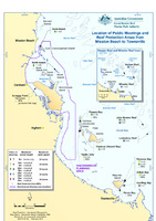 View/Open |
Items in ELibrary are protected by copyright, with all rights reserved, unless otherwise indicated.