Welcome to The Reef Authority
Great Barrier Reef Marine Park Authority
Please use this identifier to cite or link to this item:
https://hdl.handle.net/11017/3220

Full metadata record
| DC Field | Value | Language |
|---|---|---|
| dc.date.accessioned | 2017-07-27T03:35:56Z | - |
| dc.date.available | 2017-07-27T03:35:56Z | - |
| dc.date.copyright | 2020 | en |
| dc.date.issued | 2020 | en |
| dc.identifier.uri | https://hdl.handle.net/11017/3220 | en |
| dc.language.iso | en | en |
| dc.publisher | Great Barrier Reef Marine Park Authority | en |
| dc.relation.ispartofseries | Plan of Management | en |
| dc.relation.ispartofseries | Whitsundays Plan of Management | en |
| dc.rights | © Commonwealth of Australia. | en |
| dc.title | Map 1: Whitsundays Plan of Management detailed overview | en |
| dc.type | Map | en |
| dc.subject.asfa | Marine Parks | en |
| dc.subject.asfa | Regional Planning | en |
| dc.description.notes | SDC170706a March 2020 | en |
| dc.contributor.corpauthor | Great Barrier Reef Marine Park Authority | en |
| dc.publisher.place | Townsville | en |
| dc.subject.collection | Managing Multiple Use | en |
| dc.relation.connectiontogbrmpa | GBRMPA published this item | en |
| dc.subject.category | Information Publication Scheme | en |
| dc.subject.category | Zones, plans and maps | en |
| dc.subject.location | Townsville/Whitsunday Management Area | en |
| dc.keywords | WPOM | en |
| Appears in Collections: | Management | |
Files in This Item:
| File | Description | Size | Format | |
|---|---|---|---|---|
| 170706a-WPOM-DetailedOverview-Map1.pdf | MAP (PDF) | 1.35 MB | Adobe PDF |  View/Open |
| 170706a-WPOM-DetailedOverview-Map1.jpg | MAP (JPG) | 5.27 MB | JPEG | 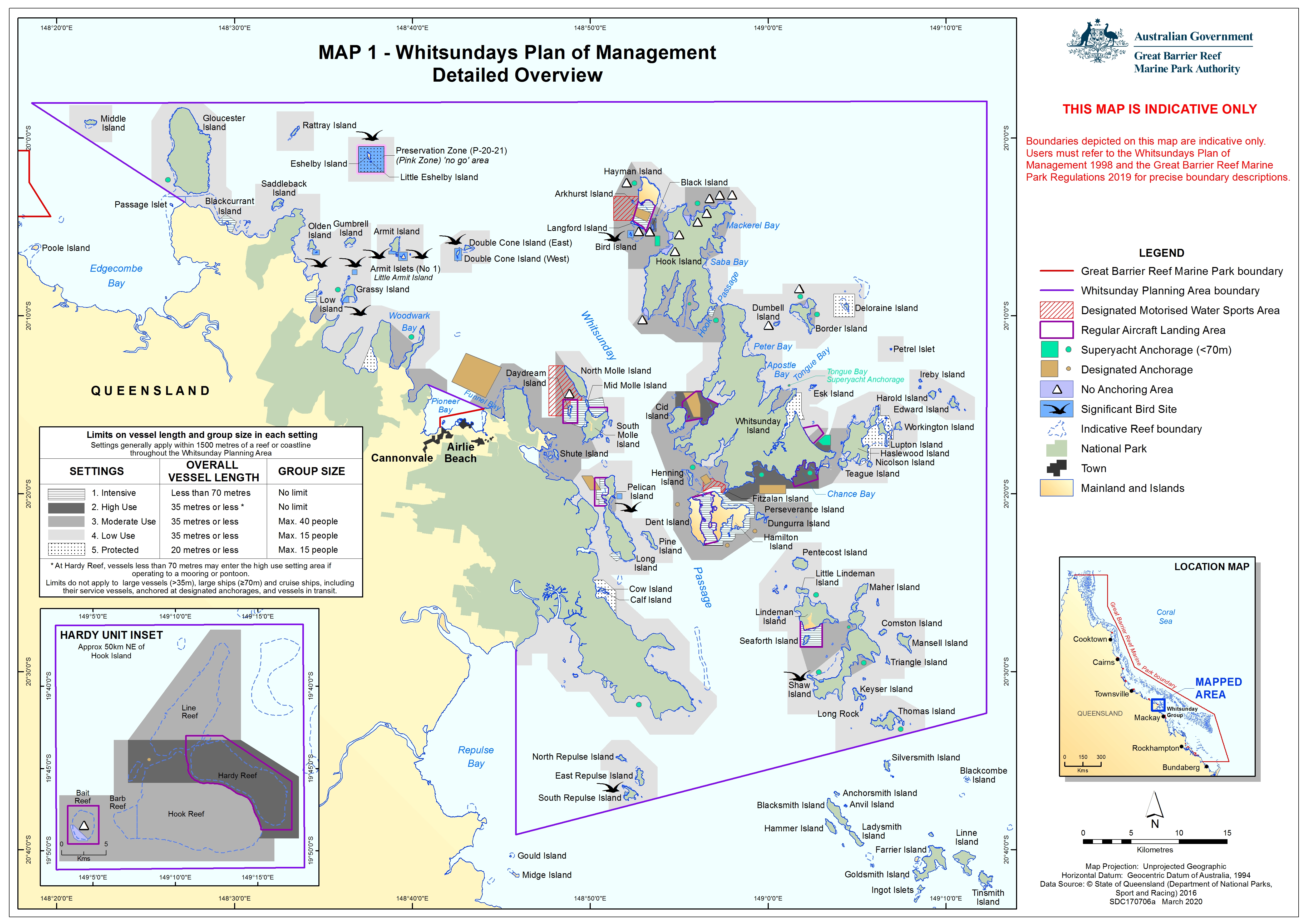 View/Open |
| SUPERSEDED-170706a-WPOM-DetailedOverview-Map1.pdf | SUPERSEDED-Overview Map - PDF | 10.24 MB | Adobe PDF |  View/Open |
Items in ELibrary are protected by copyright, with all rights reserved, unless otherwise indicated.