Welcome to The Reef Authority
Great Barrier Reef Marine Park Authority
Please use this identifier to cite or link to this item:
https://hdl.handle.net/11017/3510
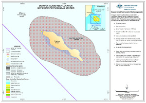
| Title: | Snapper Island Reef Location (Offshore Port Douglas Sector) |
| Authors: | Spatial Data Centre |
| metadata.dc.subject.location: | Cairns/Cooktown Management Area |
| metadata.dc.subject.category: | Cultural heritage Natural heritage Zones, plans and maps |
| Year of publication: | 2019 |
| Publisher: | Great Barrier Reef Marine Park Authority |
| Series/Report no.: | Site Arrangement |
| Abstract: | [Extract] Snapper Island a Sensitive Location with dugong habitat, indigenous cultural heritage values and is adjacent to the Daintree National Park. |
| Description: | SDC190511l June 2019. This map is indicative only. |
| URI: | https://hdl.handle.net/11017/3510 |
| Type of document: | Map |
| Appears in Collections: | Management |
Files in This Item:
| File | Description | Size | Format | |
|---|---|---|---|---|
| SDC190511l-SnapperIslandReefLocation.pdf | Map (PDF) | 6.35 MB | Adobe PDF |  View/Open |
Items in ELibrary are protected by copyright, with all rights reserved, unless otherwise indicated.