Skip navigation
Browse
Communities
& Collections
Browse Items by:
Issue Date
Author
Title
Subject
Series
Type
Submit Date
Corporate
Governance
Employee Census Highlights Report
Agency organisational structure
Annual Reports
Corporate plans
GBR outlook report
Partnerships and agreements
Policies and position statements
Information Publication Scheme
Ecosystems
& Species
Animals
Plants
Ecosystems
Processes
Geographic features
Reef
Values
Cultural heritage
National heritage
Natural heritage
World heritage
Economic values
Social values
Managing
Multiple Use
Agriculture
Coastal development
Commercial fisheries
Defence
Illegal activity
Mining
Ports and shipping
Recreation
Research
Tourism
Traditional use
Leading environmental practice
Legislative tools
Permits and assessments
Zones, plans and maps
Effects
on the Reef
Climate change
Extreme events
Incidents
Water quality
Weeds, pests and disease
People
& Actions
Coastal communities
Councils
Farmers and graziers
Fishers
Miners
Recreational users
Reef managers
Schools
Tourism operators
Traditional owners
Sign on to:
My ELibrary
Receive email
updates
Edit Profile
GBRMPA ELibrary
Search
Search:
All of ELibrary
eLibrary
Reef joint field management programme
Staff Area
for
Current filters:
Title
Author
Category
Date Issued
Equals
Contains
ID
Not Equals
Not Contains
Not ID
Title
Author
Category
Date Issued
Has File(s)
Equals
Contains
ID
Not Equals
Not Contains
Not ID
Start a new search
Add filters:
Use filters to refine the search results.
Title
Author
Category
Date Issued
Equals
Contains
ID
Not Equals
Not Contains
Not ID
Results 21-40 of 47 (Search time: 0.003 seconds).
previous
1
2
3
next
Item hits:
Preview
Issue Date
Title
Author(s)
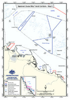
2006
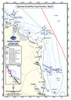
Approved Cruise Ship Transit Corridors - Map B
Great Barrier Reef Marine Park Authority
2019
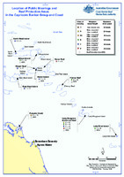
Location of public moorings and Reef protection areas in the Capricorn Bunker Group and coast
Great Barrier Reef Marine Park Authority
2006
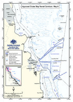
Approved Cruise Ship Transit Corridors - Map A
Great Barrier Reef Marine Park Authority
2004
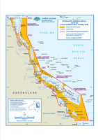
Designated Shipping Areas within the Great Barrier Reef Marine Park
Spatial Data Centre
2010
Great Barrier Reef Marine Park Authority Reef advisory committees charter of operation (SUPERSEDED)
Great Barrier Reef Marine Park Authority
2020
Douglas Shoal Remediation Project: environmental monitoring: baseline survey 2 – preliminary fieldwork report
Jones, C.
;
Brassil, W.
;
BMT Commercial Australia Pty Ltd
2013
Ship anchorage management in the Great Barrier Reef World Heritage Area
GHD
1990
Reefplan: marine pollution contingency plan for the Great Barrier Reef / Transport and Communications
Department of Transport and Communications
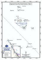
2006
Approved Cruise Ship Transit Corridors - Map D
Great Barrier Reef Marine Park Authority
2006
Approved Cruise Ship Transit Corridors - Map C
Great Barrier Reef Marine Park Authority
2017
Designated anchorages in the Great Barrier Reef Marine Park
Great Barrier Reef Marine Park Authority
;
Queensland Government
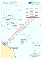
2018
Location of public moorings and Reef protection areas in the Capricorn Bunker group (SUPERSEDED)
Great Barrier Reef Marine Park Authority
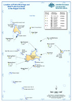
2019
Location of public moorings and Reef protection areas in the Keppel Islands
Great Barrier Reef Marine Park Authority
2009
Great Barrier Reef Outlook Report 2009: Ports and shipping information sheet
Great Barrier Reef Marine Park Authority
2013
Great Barrier Reef Region Strategic Assessment: Strategic assessment report. Draft for public comment
Great Barrier Reef Marine Park Authority
2017
Draft Policy - Cruise ship operations within the Great Barrier Reef
Great Barrier Reef Marine Park Authority
2019
Douglas Shoal Remediation Project: environmental monitoring: baseline survey 1 – preliminary fieldwork report
Jones, C.
;
Brassil, W.
;
BMT Commercial Australia Pty Ltd
2006
State of the Reef Report 2006: Shipping and oil spills
Aston, J.
;
Great Barrier Reef Marine Park Authority
2012
Guidelines on the use of hydrodynamic numerical modelling for dredging projects in the Great Barrier Reef Marine Park August 2012
Great Barrier Reef Marine Park Authority
2013
Ports and shipping information sheet - MAY 2013
Great Barrier Reef Marine Park Authority
Results 21-40 of 47 (Search time: 0.003 seconds).
previous
1
2
3
next
Discover
Author
2
Brassil, W.
2
Brinkman, R.
2
Jones, C.
2
Jones, R.
2
Rasheed, M.
2
Schaffelke, B.
1
Apte, S.
1
Aston, J.
1
Blount, C.
1
Bohensky, E.
.
next >
Category
11
Tourism
10
Information Publication Scheme
10
Recreation
9
Incidents
7
Coastal development
6
Natural heritage
6
Water quality
6
Zones, plans and maps
5
Climate change
5
Ecosystems
.
next >
Date issued
3
2020 - 2029
30
2010 - 2019
7
2000 - 2009
5
1990 - 1999
2
1985 - 1989