Skip navigation
Browse
Communities
& Collections
Browse Items by:
Issue Date
Author
Title
Subject
Series
Type
Submit Date
Corporate
Governance
Employee Census Highlights Report
Agency organisational structure
Annual Reports
Corporate plans
GBR outlook report
Partnerships and agreements
Policies and position statements
Information Publication Scheme
Ecosystems
& Species
Animals
Plants
Ecosystems
Processes
Geographic features
Reef
Values
Cultural heritage
National heritage
Natural heritage
World heritage
Economic values
Social values
Managing
Multiple Use
Agriculture
Coastal development
Commercial fisheries
Defence
Illegal activity
Mining
Ports and shipping
Recreation
Research
Tourism
Traditional use
Leading environmental practice
Legislative tools
Permits and assessments
Zones, plans and maps
Effects
on the Reef
Climate change
Extreme events
Incidents
Water quality
Weeds, pests and disease
People
& Actions
Coastal communities
Councils
Farmers and graziers
Fishers
Miners
Recreational users
Reef managers
Schools
Tourism operators
Traditional owners
Sign on to:
My ELibrary
Receive email
updates
Edit Profile
GBRMPA ELibrary
Search
Search:
All of ELibrary
eLibrary
Management
for
Current filters:
Title
Author
Category
Date Issued
Equals
Contains
ID
Not Equals
Not Contains
Not ID
Title
Author
Category
Date Issued
Equals
Contains
ID
Not Equals
Not Contains
Not ID
Start a new search
Add filters:
Use filters to refine the search results.
Title
Author
Category
Date Issued
Equals
Contains
ID
Not Equals
Not Contains
Not ID
Results 31-40 of 57 (Search time: 0.002 seconds).
previous
1
2
3
4
5
6
next
Item hits:
Preview
Issue Date
Title
Author(s)
2019
Double Bay (East) site plan
Great Barrier Reef Marine Park Authority
2019
Haslewood and Lupton Island site plan
Great Barrier Reef Marine Park Authority
2019
Cow and Calf Islands site plan
Great Barrier Reef Marine Park Authority
2019
Great Barrier Reef catchment areas and general reference map
Spatial Data Centre
2019
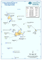
Location of public moorings and Reef protection areas in the Keppel Islands
Great Barrier Reef Marine Park Authority
2019
LIzard Island Localities (Lizard Island Sector)
Spatial Data Centre
2019
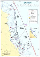
Map 1: Cairns Area Plan of Management: Overview
Spatial Data Centre
2019
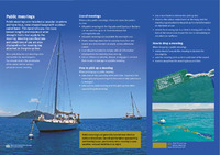
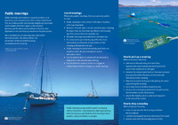
Public moorings and anchoring in the southern Great Barrier Reef: protecting coral in the Keppels and Capricorn Bunkers
Great Barrier Reef Marine Park Authority, Commonwealth Government
;
Queensland Parks and Wildlife Service, Department of Environment and Science, Queensland Government
2019
Public moorings and anchoring in the northern Great Barrier Reef: protecting coral at North Queensland's islands and reefs
Great Barrier Reef Marine Park Authority
;
Queensland Parks and Wildlife Service, Department of Environment and Science, Queensland Government
2019
Cost recovery implementation statement: cost recovery for managing the permission system under the Great Barrier Reef Marine Park Act 1975: 2018-2019
Great Barrier Reef Marine Park Authority
Discover
Author
1
Udy, J.
Category
35
Zones, plans and maps
19
Cultural heritage
16
Natural heritage
14
Tourism
11
Information Publication Scheme
11
Permits and assessments
9
Recreation
4
Ports and shipping
3
Recreational users
2
Economic values
.
next >