Welcome to The Reef Authority
Great Barrier Reef Marine Park Authority
Please use this identifier to cite or link to this item:
https://hdl.handle.net/11017/608
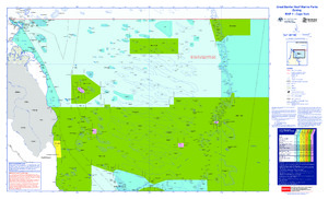
| Title: | Great Barrier Reef Marine Parks Zoning MAP 1 - Cape York |
| Authors: | Great Barrier Reef Marine Park Authority |
| metadata.dc.subject.asfa: | Coastal zone management Maps |
| APAIS Subject: | Environmental management Mapping |
| metadata.dc.subject.location: | Far Northern Management Area |
| metadata.dc.subject.category: | Information Publication Scheme Zones, plans and maps |
| Year of publication: | 2017 |
| Publisher: | Great Barrier Reef Marine Park Authority |
| Series/Report no.: | Zoning Maps Great Barrier Reef Zoning Maps |
| Abstract: | Zoning map of Cape York - edition V |
| URI: | https://hdl.handle.net/11017/608 |
| Type of document: | Map |
| Appears in Collections: | Management |
Files in This Item:
| File | Description | Size | Format | |
|---|---|---|---|---|
| WEB_Map1_Merge.pdf | Current | 9.63 MB | Adobe PDF |  View/Open |
| SUPERSEDED-Map1-Cape-York-2011.pdf | Superseded | 2.83 MB | Adobe PDF | 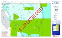 View/Open |
| Superseded-Map1-EditionV-Cape-York.pdf | Superceded | 2.34 MB | Adobe PDF |  View/Open |
Items in ELibrary are protected by copyright, with all rights reserved, unless otherwise indicated.