Please use this identifier to cite or link to this item:
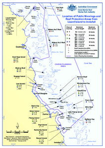
https://hdl.handle.net/11017/3379Location of public moorings and Reef Protection Areas from Lizard Island to Innisfail
View this entry
Full metadata record
| DC Field | Value | Language |
|---|---|---|
| dc.date.accessioned | 2018-05-18T02:24:36Z | - |
| dc.date.available | 2018-05-18T02:24:36Z | - |
| dc.date.copyright | 2019 | en |
| dc.date.issued | 2019 | en |
| dc.identifier.uri | http://hdl.handle.net/11017/3379 | - |
| dc.description | SDC121013a | en |
| dc.description.abstract | [Extract] Some places in the Cairns Area have special values so there are rules in place to protect these areas. Some of the rules relating to anchoring and mooring are summarised in this document. Public moorings are installed at popular locations and have blue double cone-shaped buoys with a colour-coded band attached. This band tells you the class (vessel length), time limits and maximum wind strength limits applying to the mooring. A large number of privately-owned moorings also exist in the marine parks and you should have the owner’s permission before using these moorings. | en |
| dc.publisher | Great Barrier Reef Marine Park Authority | en |
| dc.rights | © Commonwealth of Australia | en |
| dc.title | Location of public moorings and Reef Protection Areas from Lizard Island to Innisfail | en |
| dc.type | Map | en |
| dc.subject.asfa | Charts (maps) | en |
| dc.subject.asfa | Moorings | en |
| dc.subject.asfa | Protection | en |
| dc.format.pages | 4 | en |
| dc.contributor.corpauthor | Great Barrier Reef Marine Park Authority | en |
| dc.publisher.place | Townsville | en |
| dc.subject.collection | Managing Multiple Use | en |
| dc.relation.connectiontogbrmpa | GBRMPA published this item | en |
| dc.subject.category | Ports and shipping | en |
| dc.subject.category | Recreation | en |
| dc.subject.category | Tourism | en |
| dc.keywords | RPA | en |
| Appears in Collections: | Management | |
Files in This Item:
| File | Description | Size | Format | |
|---|---|---|---|---|
| Lizard-Is-Innisfail-Moorings-Access.PDF | MAP (PDF) | 1.02 MB | Adobe PDF |  View/Open |
Items in the ELibrary are protected by copyright, with all rights reserved, unless otherwise indicated.