Skip navigation
Browse
Communities
& Collections
Browse Items by:
Issue Date
Author
Title
Subject
Series
Type
Submit Date
Corporate
Governance
Employee Census Highlights Report
Agency organisational structure
Annual Reports
Corporate plans
GBR outlook report
Partnerships and agreements
Policies and position statements
Information Publication Scheme
Ecosystems
& Species
Animals
Plants
Ecosystems
Processes
Geographic features
Reef
Values
Cultural heritage
National heritage
Natural heritage
World heritage
Economic values
Social values
Managing
Multiple Use
Agriculture
Coastal development
Commercial fisheries
Defence
Illegal activity
Mining
Ports and shipping
Recreation
Research
Tourism
Traditional use
Leading environmental practice
Legislative tools
Permits and assessments
Zones, plans and maps
Effects
on the Reef
Climate change
Extreme events
Incidents
Water quality
Weeds, pests and disease
People
& Actions
Coastal communities
Councils
Farmers and graziers
Fishers
Miners
Recreational users
Reef managers
Schools
Tourism operators
Traditional owners
Sign on to:
My ELibrary
Receive email
updates
Edit Profile
GBRMPA ELibrary
Browsing by Title
Jump to:
0-9
A
B
C
D
E
F
G
H
I
J
K
L
M
N
O
P
Q
R
S
T
U
V
W
X
Y
Z
or enter first few letters:
Sort by:
issue date
title
submit date
In order:
Ascending
Descending
Results/Page
5
10
15
20
25
30
35
40
45
50
55
60
65
70
75
80
85
90
95
100
Authors/Record:
All
1
5
10
15
20
25
30
35
40
45
50
Showing results 955 to 974 of 1968
< previous
next >
Preview
Issue Date
Title
Author(s)
2016
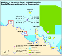
Location of Maritime Cultural Heritage Protection Special Management Area in the Bowen region
Spatial Data Centre
2016
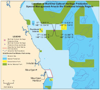
Location of Maritime Cultural Heritage Protection Special Management Area in the Frankland Islands region
Spatial Data Centre
2019
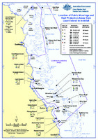
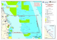
Location of public moorings and Reef Protection Areas from Lizard Island to Innisfail
Great Barrier Reef Marine Park Authority
2019
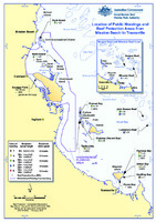
Location of public moorings and Reef Protection Areas from Mission Beach to Townsville
Great Barrier Reef Marine Park Authority
2018
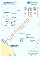
Location of public moorings and Reef protection areas in the Capricorn Bunker group (SUPERSEDED)
Great Barrier Reef Marine Park Authority
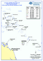
2019
Location of public moorings and Reef protection areas in the Capricorn Bunker Group and coast
Great Barrier Reef Marine Park Authority
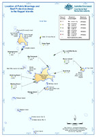
2019
Location of public moorings and Reef protection areas in the Keppel Islands
Great Barrier Reef Marine Park Authority
2021
Location of public moorings and Reef protection areas in the Whitsundays
Great Barrier Reef Marine Park Authority
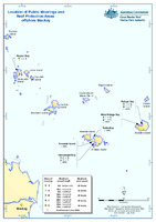
2019
Location of public moorings and Reef protection areas offshore Mackay
Great Barrier Reef Marine Park Authority
2017
Location-specific assessment
Great Barrier Reef Marine Park Authority
2002
Long term monitoring program for marine benthos in the vicinity of Keswick Island Development (Whitsunday Island group): baseline survey
Ayling, A.M.
;
Ayling, A.L.
;
Sea Research
1998
Long-term chlorophyll monitoring in the Great Barrier Reef Lagoon : status report 1, 1993-1995
Steven, A.D.L.
;
Pantus, F.
;
Brooks, D.
;
Trott, L.
;
Great Barrier Reef Marine Park Authority
1997
Long-term trends in the status of coral-flat benthos: the use of historical photographs.
Wachenfeld, D.
2023
Love the Reef Toolkit
Great Barrier Reef Marine Park Authority
2019
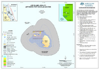
Low Island Locality (Offshore Port Douglas Sector)
Spatial Data Centre
1993
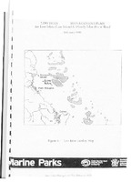
Low Isles management plan for Low Islets (Low Island and Woody Island) and Reef : February 1993
Great Barrier Reef Marine Park Authority
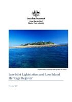
2018
Low Islet Lightstation and Low Island Heritage Register
Great Barrier Reef Marine Park Authority
1987
Mackay/Capricorn section zoning plan : Great Barrier Reef Marine Park
Great Barrier Reef Marine Park Authority
1992
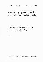
Magnetic Quay water quality and sediment baseline study 1989
Brodie, J.E.
;
Mapstone, B.D.
;
Mitchell, R.L.
2008
Mamu TUMRA Region Schedule 2 Map
Great Barrier Reef Marine Park Authority