Skip navigation
Browse
Communities
& Collections
Browse Items by:
Issue Date
Author
Title
Subject
Series
Type
Submit Date
Corporate
Governance
Employee Census Highlights Report
Agency organisational structure
Annual Reports
Corporate plans
GBR outlook report
Partnerships and agreements
Policies and position statements
Information Publication Scheme
Ecosystems
& Species
Animals
Plants
Ecosystems
Processes
Geographic features
Reef
Values
Cultural heritage
National heritage
Natural heritage
World heritage
Economic values
Social values
Managing
Multiple Use
Agriculture
Coastal development
Commercial fisheries
Defence
Illegal activity
Mining
Ports and shipping
Recreation
Research
Tourism
Traditional use
Leading environmental practice
Legislative tools
Permits and assessments
Zones, plans and maps
Effects
on the Reef
Climate change
Extreme events
Incidents
Water quality
Weeds, pests and disease
People
& Actions
Coastal communities
Councils
Farmers and graziers
Fishers
Miners
Recreational users
Reef managers
Schools
Tourism operators
Traditional owners
Sign on to:
My ELibrary
Receive email
updates
Edit Profile
GBRMPA ELibrary
Search
Search:
All of ELibrary
eLibrary
Reef joint field management programme
Staff Area
for
Current filters:
Title
Author
Category
Date Issued
Equals
Contains
ID
Not Equals
Not Contains
Not ID
Title
Author
Category
Date Issued
Equals
Contains
ID
Not Equals
Not Contains
Not ID
Start a new search
Add filters:
Use filters to refine the search results.
Title
Author
Category
Date Issued
Equals
Contains
ID
Not Equals
Not Contains
Not ID
Results 41-60 of 106 (Search time: 0.005 seconds).
previous
1
2
3
4
5
6
next
Item hits:
Preview
Issue Date
Title
Author(s)
2017
Great Barrier Reef Marine Parks Zoning MAP 13 - Hardline Reefs
Great Barrier Reef Marine Park Authority
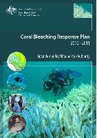
2010
Coral Bleaching Response Plan 2010-2011
Great Barrier Reef Marine Park Authority
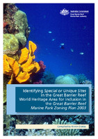
2011
Identifying special or unique sites in the Great Barrier Reef World Heritage area for inclusion in the Great Barrier Reef Marine Park Zoning Plan 2003
Dobbs, K.
;
Great Barrier Reef Marine Park Authority
2013
Reef Beat education series: the amazing Great Barrier Reef, let's keep it great
Great Barrier Reef Marine Park Authority
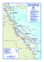
2012
Great Barrier Reef general reference map
Great Barrier Reef Marine Park Authority
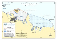
2013
Cleveland Bay and Bowling Green Bay dugong protected areas
Great Barrier Reef Marine Park Authority
2013
Mesophotic coral reef ecosystems in the Great Barrier Reef World Heritage Area
Bridge, T.
;
Guinotte, J.
;
Great Barrier Reef Marine Park Authority
2013
Hinchinbrook and Taylors Beach dugong protection areas
Great Barrier Reef Marine Park Authority
2016
Site Management Arrangements: Lady Musgrave Reef (23-082): Supporting Information
Great Barrier Reef Marine Park Authority
2017
Great Barrier Reef Marine Parks Zoning MAP 19 - Offshore Capricorn
Great Barrier Reef Marine Park Authority
2019
Hope Islands Reefs (Offshore Port Douglas Sector)
Spatial Data Centre
2019
Frankland Islands Sector
Spatial Data Centre
2018
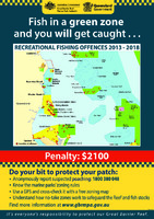
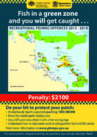
Fish in a green zone and you will get caught...Recreational fishing offences 2013-2018 Mission Beach
Great Barrier Reef Marine Park Authority
;
Queensland Government
2018
Fish in a green zone and you will get caught...Recreational fishing offences 2013-2018 Mackay
Great Barrier Reef Marine Park Authority
;
Queensland Government
2018
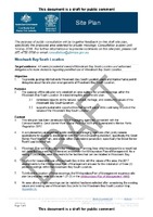
Site Plan: Woodwark Bay South location: draft for public consultation
Great Barrier Reef Marine Park Authority
;
Queensland Government
2011
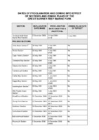
Dates of proclamation and coming into effect of sections and zoning plans of the Great Barrier Reef Marine Park
Great Barrier Reef Marine Park Authority
2019
LIzard Island Localities (Lizard Island Sector)
Spatial Data Centre
2019
Public moorings and anchoring in the southern Great Barrier Reef: protecting coral in the Keppels and Capricorn Bunkers
Great Barrier Reef Marine Park Authority, Commonwealth Government
;
Queensland Parks and Wildlife Service, Department of Environment and Science, Queensland Government
2020
Whitsundays Plan of Management: Tongue Bay, Hill Inlet and Whitehaven Beach, Whitsunday Island
Spatial Data Centre
2018
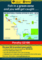
Fish in a green zone and you will get caught...Recreational fishing offences 2013-2018 Gladstone
Great Barrier Reef Marine Park Authority
;
Queensland Government
Results 41-60 of 106 (Search time: 0.005 seconds).
previous
1
2
3
4
5
6
next
Discover
Author
1
Bridge, T.
1
Ceccarelli, D.M.
1
Dobbs, K.
1
Emslie, M.
1
Gilligan, B.
1
Guinotte, J.
1
Hockings, M.
1
Jones, G.P.
1
Leverington, A.
1
Logan, M.
.
next >
Category
34
Information Publication Scheme
20
Cultural heritage
17
Natural heritage
14
Recreation
12
Legislative tools
10
Animals
10
Tourism
8
Recreational users
7
Illegal activity
5
Fishers
.
next >
Date issued
38
2019
20
2017
11
2013
11
2018
8
2020
6
2016
4
2015
3
2011
3
2014
1
2010
.
next >