Welcome to The Reef Authority
Great Barrier Reef Marine Park Authority
Please use this identifier to cite or link to this item:
https://hdl.handle.net/11017/863
Full metadata record
| DC Field | Value | Language |
|---|---|---|
| dc.date.accessioned | 2012-10-29T04:36:34Z | null |
| dc.date.available | 2012-10-29T04:36:34Z | null |
| dc.date.copyright | 2008 | en |
| dc.date.issued | 2008 | en-US |
| dc.date.issued | 2008 | en |
| dc.identifier.uri | https://hdl.handle.net/11017/863 | en |
| dc.language.iso | en | en |
| dc.publisher | Great Barrier Reef Marine Park Authority | en |
| dc.relation.ispartofseries | Plan of Management | en |
| dc.relation.isreplacedby | https://hdl.handle.net/11017/3253 | en |
| dc.rights | © Commonwealth of Australia. | en |
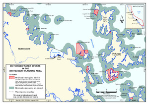
| dc.title | Motorised water sports in the Whitsundays planning area 2008 (SUPERSEDED) | en |
| dc.type | Map | * |
| dc.type | Map | en |
| dc.subject.asfa | Maps | en |
| dc.contributor.corpauthor | Great Barrier Reef Marine Park Authority | en |
| dc.subject.apais | Environmental management | en |
| dc.publisher.place | Townsville | en |
| dc.subject.collection | Managing Multiple Use | en |
| dc.relation.connectiontogbrmpa | GBRMPA published this item | en |
| dc.subject.category | Information Publication Scheme | en |
| dc.subject.category | Zones, plans and maps | en |
| dc.subject.location | Townsville/Whitsunday Management Area | en |
| dcterms.abstract | This map is replaced by 'Map 2: Whitsundays Plan of Management motorised water sports' areas available at http://hdl.handle.net/11017/3253 | en |
| Appears in Collections: | Management | |
Files in This Item:
| File | Description | Size | Format | |
|---|---|---|---|---|
| SUPERSEDED-whitsundays-motorised-water-sports-map-2008.pdf | Map (SUPERSEDED) | 873.41 kB | Adobe PDF | 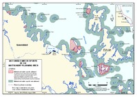 View/Open |
Items in ELibrary are protected by copyright, with all rights reserved, unless otherwise indicated.