Please use this identifier to cite or link to this item:
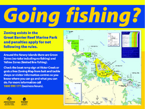
https://hdl.handle.net/11017/629Going fishing? Zoning in the Newry Islands, Seaforth 2009
View this entry
Full metadata record
| DC Field | Value | Language |
|---|---|---|
| dc.date.accessioned | 2012-10-24T01:01:15Z | null |
| dc.date.available | 2012-10-24T01:01:15Z | null |
| dc.date.copyright | 2009 | en |
| dc.date.issued | 2009 | en-US |
| dc.identifier.uri | http://hdl.handle.net/11017/629 | null |
| dc.publisher | Great Barrier Reef Marine Park Authority | en |
| dc.title | Going fishing? Zoning in the Newry Islands, Seaforth 2009 | en |
| dc.type | Brochure | * |
| dc.subject.asfa | Recreational fishing | en |
| dc.format.pages | 1 | en |
| dc.contributor.corpauthor | Great Barrier Reef Marine Park Authority | en |
| dc.subject.apais | Environmental management | en |
| dc.publisher.place | Townsville | en |
| dc.subject.collection | Managing Multiple Use | en |
| dc.relation.connectiontogbrmpa | GBRMPA published this item | en |
| dc.subject.category | Information Publication Scheme | en |
| dc.subject.category | Recreation | en |
| dc.subject.category | Zones, plans and maps | en |
| dc.subject.location | Reef-wide | en |
| Appears in Collections: | Management | |
Files in This Item:
| File | Description | Size | Format | |
|---|---|---|---|---|
| Going-fishing-Seaforth-zoning-sign.pdf | 5.26 MB | Adobe PDF |  View/Open |
Items in the ELibrary are protected by copyright, with all rights reserved, unless otherwise indicated.