Welcome to The Reef Authority
Great Barrier Reef Marine Park Authority
Please use this identifier to cite or link to this item:
https://hdl.handle.net/11017/3619
Full metadata record
| DC Field | Value | Language |
|---|---|---|
| dc.coverage.spatial | Cairns | en |
| dc.coverage.spatial | Daintree | en |
| dc.coverage.spatial | Green Island | en |
| dc.coverage.spatial | Cairns Planning Area | en |
| dc.coverage.spatial | Bramston Beach | en |
| dc.date.accessioned | 2020-07-14T04:08:12Z | - |
| dc.date.available | 2020-07-14T04:08:12Z | - |
| dc.date.copyright | 2019 | en |
| dc.date.issued | 2019 | en |
| dc.identifier.uri | https://hdl.handle.net/11017/3619 | - |
| dc.description | SDC181204b August 2019 | en |
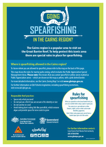
| dc.description.abstract | Going spearfishing in the Cairns region? For ease of understanding, this map shows the areas opened and closed to spearfishing (such as green zones) under marine parks zoning legislation in the Cairns Planning Area, south of the Daintree (Qld). | en |
| dc.publisher | Great Barrier Reef Marine Park Authority | en |
| dc.relation.ispartofseries | Spearfishing in the Marine Park | en |
| dc.rights | © Commonwealth of Australia. | en |
| dc.title | Going Spearfishing in the Cairns region | en |
| dc.type | Map | en |
| dc.subject.asfa | Spear fishing | en |
| dc.subject.asfa | Recreational fishing | en |
| dc.format.pages | 2 | en |
| dc.contributor.corpauthor | Great Barrier Reef Marine Park Authority | en |
| dc.subject.collection | Managing Multiple Use | en |
| dc.relation.connectiontogbrmpa | GBRMPA published this item | en |
| dc.subject.category | Information Publication Scheme | en |
| dc.subject.category | Recreation | en |
| dc.subject.category | Zones, plans and maps | en |
| dc.subject.category | Fishers | en |
| dc.subject.category | Recreational users | en |
| dc.subject.location | Cairns/Cooktown Management Area | en |
| dc.keywords | Rules | en |
| dc.keywords | Responsible Reef practices | en |
| dc.keywords | CAPOM | en |
| Appears in Collections: | Management | |
Files in This Item:
| File | Description | Size | Format | |
|---|---|---|---|---|
| Spearfishing-in-Cairns-2019.pdf | Map (PDF) | 852.52 kB | Adobe PDF |  View/Open |
Items in ELibrary are protected by copyright, with all rights reserved, unless otherwise indicated.