Welcome to The Reef Authority
Great Barrier Reef Marine Park Authority
Please use this identifier to cite or link to this item:
https://hdl.handle.net/11017/3573
Full metadata record
| DC Field | Value | Language |
|---|---|---|
| dc.coverage.spatial | Whitsunday Island | en |
| dc.coverage.spatial | Haslewood Island | en |
| dc.coverage.spatial | Tongue Point | en |
| dc.coverage.spatial | Whitehaven Beach | en |
| dc.coverage.spatial | Hill Inlet | en |
| dc.date.accessioned | 2020-03-17T00:37:10Z | - |
| dc.date.available | 2020-03-17T00:37:10Z | - |
| dc.date.copyright | 2020 | en |
| dc.date.issued | 2020 | en |
| dc.identifier.uri | https://hdl.handle.net/11017/3573 | - |
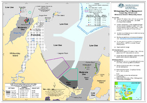
| dc.description | SDC 190811 - March 2020. | en |
| dc.publisher | Great Barrier Reef Marine Park Authority | en |
| dc.rights | © Commonwealth of Australia (GBRMPA). This publication is licensed by the Commonwealth of Australia for use under a Creative Commons By Attribution 4.0 International licence with the exception of the Coat of Arms of the Commonwealth of Australia and the logo of the Great Barrier Reef Marine Park Authority. For licence conditions see: http://creativecommons.org/licences/by/4.0 | en |
| dc.title | Whitsundays Plan of Management: Tongue Bay, Hill Inlet and Whitehaven Beach, Whitsunday Island | en |
| dc.type | Map | en |
| dc.subject.asfa | Boating | en |
| dc.format.pages | 1 | en |
| dc.contributor.corpauthor | Spatial Data Centre | en |
| dc.publisher.place | Townsville | en |
| dc.subject.collection | Managing Multiple Use | en |
| dc.relation.connectiontogbrmpa | GBRMPA published this item | en |
| dc.subject.category | Zones, plans and maps | en |
| dc.subject.location | Townsville/Whitsunday Management Area | en |
| dc.keywords | WPOM | en |
| Appears in Collections: | Management | |
Files in This Item:
| File | Description | Size | Format | |
|---|---|---|---|---|
| WPOM-TongueBay-HillInlet-Whitehaven-Whitsunday.pdf | Map (PDF) | 1.18 MB | Adobe PDF | 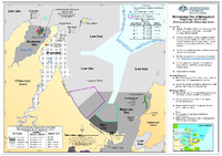 View/Open |
This item is licensed under a Creative Commons License
