Welcome to The Reef Authority
Great Barrier Reef Marine Park Authority
Please use this identifier to cite or link to this item:
https://hdl.handle.net/11017/3496
Full metadata record
| DC Field | Value | Language |
|---|---|---|
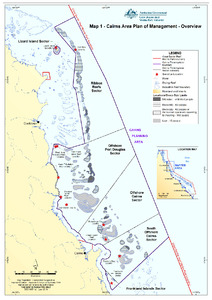
| dc.coverage.spatial | LIzard Island | en |
| dc.coverage.spatial | Cooktown | en |
| dc.coverage.spatial | Ribbon Reefs Sector | en |
| dc.coverage.spatial | Offshore Port Douglas Sector | en |
| dc.coverage.spatial | Cairns Planning Area | en |
| dc.coverage.spatial | Offshore Cairns Sector | en |
| dc.coverage.spatial | Frankland Islands Sector | en |
| dc.date.accessioned | 2019-09-17T04:43:53Z | - |
| dc.date.available | 2019-09-17T04:43:53Z | - |
| dc.date.copyright | 2019 | en |
| dc.date.issued | 2019 | en |
| dc.identifier.uri | https://hdl.handle.net/11017/3496 | - |
| dc.description | SDC190511a, June 2019. This map is indicative only. | en |
| dc.publisher | Great Barrier Reef Marine Park Authority | en |
| dc.relation.ispartofseries | Plan of Management | en |
| dc.rights | © Commonwealth of Australia (GBRMPA) | en |
| dc.title | Map 1: Cairns Area Plan of Management: Overview | en |
| dc.type | Map | en |
| dc.format.pages | 1 | en |
| dc.description.notes | This map replaces the 'Cairns Planning Area', Map no. SDC070203a, August 2008. | en |
| dc.contributor.corpauthor | Spatial Data Centre | en |
| dc.publisher.place | Townsville | en |
| dc.subject.collection | Managing Multiple Use | en |
| dc.relation.connectiontogbrmpa | GBRMPA published this item | en |
| dc.subject.location | Cairns/Cooktown Management Area | en |
| dc.keywords | POM | en |
| dc.keywords | CPOM | en |
| Appears in Collections: | Management | |
Files in This Item:
| File | Description | Size | Format | |
|---|---|---|---|---|
| SDC190511a-Map1CairnsAreaPlanOfManagement-Overview.pdf | Map (PDF) | 7.39 MB | Adobe PDF |  View/Open |
Items in ELibrary are protected by copyright, with all rights reserved, unless otherwise indicated.