Welcome to The Reef Authority
Great Barrier Reef Marine Park Authority
Please use this identifier to cite or link to this item:
https://hdl.handle.net/11017/3392
Full metadata record
| DC Field | Value | Language |
|---|---|---|
| dc.date.accessioned | 2018-07-20T03:48:32Z | - |
| dc.date.available | 2018-07-20T03:48:32Z | - |
| dc.date.copyright | 2024 | en |
| dc.date.issued | 2024 | en |
| dc.identifier.uri | https://hdl.handle.net/11017/3392 | - |
| dc.publisher | Great Barrier Reef Marine Park Authority | en |
| dc.rights | © Commonwealth of Australia | en |
| dc.title | Location of public moorings and Reef protection areas in the Keppel Islands (updated December 2024) | en |
| dc.type | Map | en |
| dc.subject.asfa | Moorings | en |
| dc.subject.asfa | Protection | en |
| dc.subject.asfa | Charts (maps) | en |
| dc.format.pages | 4 | en |
| dc.contributor.corpauthor | Great Barrier Reef Marine Park Authority | en |
| dc.publisher.place | Townsville | en |
| dc.subject.collection | Managing Multiple Use | en |
| dc.relation.connectiontogbrmpa | GBRMPA published this item | en |
| dc.subject.category | Ports and shipping | en |
| dc.subject.category | Recreation | en |
| dc.subject.category | Tourism | en |
| dc.subject.location | Mackay/Capricorn Management Area | en |
| dc.keywords | RPA | en |
| Appears in Collections: | Management | |
Files in This Item:
| File | Description | Size | Format | |
|---|---|---|---|---|
| 2024-11-Public-Moorings-Map-Keppels.pdf | 716.13 kB | Adobe PDF |  View/Open | |
| SUPERSEDED VERSION Location of Public Moorings and Reef Protection areas in the Keppel Islands.pdf | 535.84 kB | Adobe PDF | 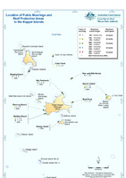 View/Open |
Items in ELibrary are protected by copyright, with all rights reserved, unless otherwise indicated.