Welcome to The Reef Authority
Great Barrier Reef Marine Park Authority
Please use this identifier to cite or link to this item:
https://hdl.handle.net/11017/3319

Full metadata record
| DC Field | Value | Language |
|---|---|---|
| dc.date.accessioned | 2017-12-14T23:29:53Z | - |
| dc.date.available | 2017-12-14T23:29:53Z | - |
| dc.date.copyright | 2024 | en |
| dc.date.issued | 2024 | en |
| dc.identifier.uri | https://hdl.handle.net/11017/3319 | - |
| dc.description.abstract | The Whitsundays region is one of the most highly visited regions of the Great Barrier Reef. The Whitsundays Plan of Management is in place to help protect the values and minimise disturbance. This map and accompanying notes gives some basic information on public moorings and Reef Protection Areas. For further information visit www.gbrmpa.gov.au. | en |
| dc.publisher | Great Barrier Reef Marine Park Authority | en |
| dc.rights | Commonwealth of Australia. | en |
| dc.title | Location of public moorings and Reef protection areas in the Whitsundays (updated December 2024) | en |
| dc.type | Map | en |
| dc.subject.asfa | Moorings | en |
| dc.subject.asfa | Boating | en |
| dc.format.pages | 8 | en |
| dc.description.notes | SDC121013c | en |
| dc.contributor.corpauthor | Great Barrier Reef Marine Park Authority | en |
| dc.subject.apais | Boats | en |
| dc.publisher.place | Townsville | en |
| dc.subject.collection | Managing Multiple Use | en |
| dc.relation.connectiontogbrmpa | GBRMPA published this item | en |
| dc.subject.category | Zones, plans and maps | en |
| dc.subject.location | Townsville/Whitsunday Management Area | en |
| Appears in Collections: | Management | |
Files in This Item:
| File | Description | Size | Format | |
|---|---|---|---|---|
| 2024-11-Public-Moorings-Map-Whitsundays.pdf | 6.22 MB | Adobe PDF | 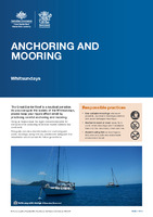 View/Open | |
| SUPERSEDED VERSION Location of Public Moorings and Reef Protection areas in WhitSundays.pdf | 2.28 MB | Adobe PDF |  View/Open |
Items in ELibrary are protected by copyright, with all rights reserved, unless otherwise indicated.