Welcome to The Reef Authority
Great Barrier Reef Marine Park Authority
Please use this identifier to cite or link to this item:
https://hdl.handle.net/11017/3001
Full metadata record
| DC Field | Value | Language |
|---|---|---|
| dc.coverage.spatial | Seaforth | en |
| dc.coverage.spatial | Proserpine River | en |
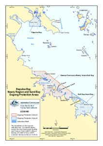
| dc.coverage.spatial | Repulse Bay | en |
| dc.coverage.spatial | St Helens Bay | en |
| dc.coverage.spatial | Sand Bay | en |
| dc.date.accessioned | 2016-04-26T03:46:08Z | - |
| dc.date.available | 2016-04-26T03:46:08Z | - |
| dc.date.copyright | 2013 | en |
| dc.date.issued | 2013 | en |
| dc.identifier.uri | https://hdl.handle.net/11017/3001 | - |
| dc.publisher | Great Barrier Reef Marine Park Authority | en |
| dc.relation.ispartofseries | Special Management Areas | - |
| dc.rights | Copyright Commonwealth of Australia (GBRMPA) | en |
| dc.title | Repulse Bay, Newry Region and Sand Bay dugong protection areas | en |
| dc.type | Map | en |
| dc.subject.asfa | Mammals (marine) | en |
| dc.subject.asfa | Maps | en |
| dc.subject.asfa | Protected areas | en |
| dc.contributor.corpauthor | Great Barrier Reef Marine Park Authority | en |
| dc.subject.apais | Animals | en |
| dc.subject.collection | Managing Multiple Use | en |
| dc.relation.connectiontogbrmpa | GBRMPA published this item | en |
| dc.subject.category | Animals | en |
| dc.subject.category | Zones, plans and maps | en |
| dc.subject.location | Mackay/Capricorn Management Area | en |
| Appears in Collections: | Management | |
Files in This Item:
| File | Description | Size | Format | |
|---|---|---|---|---|
| 130610e-GBRMPAandStateDPAs-RepulseBay-Newry Region-and-SandBay.pdf | Map | 597.53 kB | Adobe PDF | 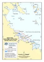 View/Open |
Items in ELibrary are protected by copyright, with all rights reserved, unless otherwise indicated.