Skip navigation
Browse
Communities
& Collections
Browse Items by:
Issue Date
Author
Title
Subject
Series
Type
Submit Date
Corporate
Governance
Employee Census Highlights Report
Agency organisational structure
Annual Reports
Corporate plans
GBR outlook report
Partnerships and agreements
Policies and position statements
Information Publication Scheme
Ecosystems
& Species
Animals
Plants
Ecosystems
Processes
Geographic features
Reef
Values
Cultural heritage
National heritage
Natural heritage
World heritage
Economic values
Social values
Managing
Multiple Use
Agriculture
Coastal development
Commercial fisheries
Defence
Illegal activity
Mining
Ports and shipping
Recreation
Research
Tourism
Traditional use
Leading environmental practice
Legislative tools
Permits and assessments
Zones, plans and maps
Effects
on the Reef
Climate change
Extreme events
Incidents
Water quality
Weeds, pests and disease
People
& Actions
Coastal communities
Councils
Farmers and graziers
Fishers
Miners
Recreational users
Reef managers
Schools
Tourism operators
Traditional owners
Sign on to:
My ELibrary
Receive email
updates
Edit Profile
GBRMPA ELibrary
Browsing by Subject Ports and shipping
Jump to a point in the index:
(Choose year)
2024
2023
2022
2021
2020
2019
2018
2017
2016
2015
2014
2013
2012
2011
2010
2009
2008
2007
2006
2005
2004
2003
2002
2001
2000
1999
1998
1997
1996
1995
1994
1993
1992
1991
1990
1985
1980
1975
1970
1960
1950
(Choose month)
January
February
March
April
May
June
July
August
September
October
November
December
Or type in a year:
Sort by:
issue date
title
submit date
In order:
Ascending
Descending
Results/Page
5
10
15
20
25
30
35
40
45
50
55
60
65
70
75
80
85
90
95
100
Authors/Record:
All
1
5
10
15
20
25
30
35
40
45
50
Showing results 1 to 20 of 47
next >
Preview
Issue Date
Title
Author(s)
1985
Workshop on response to hazardous chemical spills in the Great Barrier Reef Region : proceedings of a workshop held in Townsville on 3 August 1984 and background papers
Craik, G.J.S.
;
Great Barrier Reef Marine Park Authority
1987
Reefplan : oil spill contingency plan for the Great Barrier Reef
Department of Transport
1990
Reefplan: marine pollution contingency plan for the Great Barrier Reef / Transport and Communications
Department of Transport and Communications
1994
Hulls, hazards and hard questions : shipping in the Great Barrier Reef : reducing the risk of spilling oil and other hazardous substances
Ottesen, P.
;
Great Barrier Reef Marine Park Authority
1995
The Queensland Nickel Management appeal : a case study of the appeals process
Hillman, S.P.
;
Great Barrier Reef Marine Park Authority
1997
Strategic plan for the management of the Whitsunday marine and national parks
Great Barrier Reef Marine Park Authority
;
Queensland Department of Environment
1999
Policy on cruise shipping for the Great Barrier Reef 1999 (REVOKED)
Great Barrier Reef Marine Park Authority
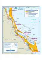
2004
Designated Shipping Areas within the Great Barrier Reef Marine Park
Spatial Data Centre
2006
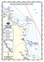
Approved Cruise Ship Transit Corridors - Map B
Great Barrier Reef Marine Park Authority
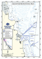
2006
Approved Cruise Ship Transit Corridors - Map A
Great Barrier Reef Marine Park Authority
2006
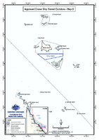
Approved Cruise Ship Transit Corridors - Map D
Great Barrier Reef Marine Park Authority
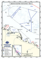
2006
Approved Cruise Ship Transit Corridors - Map C
Great Barrier Reef Marine Park Authority
2006
State of the Reef Report 2006: Shipping and oil spills
Aston, J.
;
Great Barrier Reef Marine Park Authority
2009
Great Barrier Reef Outlook Report 2009: Ports and shipping information sheet
Great Barrier Reef Marine Park Authority
2010
Great Barrier Reef Marine Park Authority Reef advisory committees charter of operation (SUPERSEDED)
Great Barrier Reef Marine Park Authority
2012
Guidelines on the use of hydrodynamic numerical modelling for dredging projects in the Great Barrier Reef Marine Park August 2012
Great Barrier Reef Marine Park Authority
2013
Ship anchorage management in the Great Barrier Reef World Heritage Area
GHD
2013
Great Barrier Reef Region Strategic Assessment: Strategic assessment report. Draft for public comment
Great Barrier Reef Marine Park Authority
2013
Ports and shipping information sheet - MAY 2013
Great Barrier Reef Marine Park Authority
2013
Great Barrier Reef Biodiversity Conservation Strategy 2013
Great Barrier Reef Marine Park Authority